


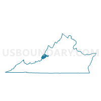
Callaghan Voting District, Alleghany County, Virginia
About
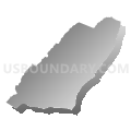
Outline

Summary
| Unique Area Identifier | 681022 |
| Name | Callaghan Voting District |
| County | Alleghany County |
| State | Virginia |
| Area (square miles) | 62.81 |
| Land Area (square miles) | 62.12 |
| Water Area (square miles) | 0.70 |
| % of Land Area | 98.89 |
| % of Water Area | 1.11 |
| Latitude of the Internal Point | 37.89642060 |
| Longtitude of the Internal Point | -80.04259110 |
Maps


Graphs
Select a template below for downloading or customizing gragh for Callaghan Voting District, Alleghany County, Virginia


Neighbors
Neighoring Voting District (by Name) Neighboring Voting District on the Map
- Voting District 1, Greenbrier County, WV
- Voting District 75, Greenbrier County, WV
- Griffith Voting District, Alleghany County, VA
- Humpback Bridge Voting District, Alleghany County, VA
- Mountain Grove Voting District, Bath County, VA
- Warm Springs Voting District, Bath County, VA
Top 10 Neighboring County Subdivision (by Population) Neighboring County Subdivision on the Map
- Eastern district, Greenbrier County, WV (11,601)
- Falling Spring district, Alleghany County, VA (2,489)
- Covington district, Alleghany County, VA (2,353)
- Warm Springs district, Bath County, VA (822)
Top 10 Neighboring Place (by Population) Neighboring Place on the Map
Top 10 Neighboring Unified School District (by Population) Neighboring Unified School District on the Map
- Greenbrier County School District, WV (35,480)
- Alleghany County Public Schools, VA (16,250)
- Bath County Public Schools, VA (4,731)
Top 10 Neighboring State Legislative District Lower Chamber (by Population) Neighboring State Legislative District Lower Chamber on the Map
Top 10 Neighboring State Legislative District Upper Chamber (by Population) Neighboring State Legislative District Upper Chamber on the Map
Top 10 Neighboring 111th Congressional District (by Population) Neighboring 111th Congressional District on the Map
Top 10 Neighboring Census Tract (by Population) Neighboring Census Tract on the Map
- Census Tract 9501, Greenbrier County, WV (5,283)
- Census Tract 9201, Bath County, VA (4,731)
- Census Tract 803.01, Alleghany County, VA (1,905)
- Census Tract 803.02, Alleghany County, VA (1,553)